OPENING QUESTIONS:
REVIEW:
Contrast tsunami waves with ocean waves giving as many differences between them as you can.
Now please compare tsunami waves with ocean waves giving as many similarities between them as you can.
LEARNING TARGET: I will be able to characterize tsunamis by wavelength, amplitude, frequency, period and speed during today's class
WORDS O' THE DAY:
- frequency (waves/second or waves/minute)
- period ("seconds/wave or minutes/wave")
- amplitude (wave height)
- wavelength (distance from crest to crest)
- crest (the highest point of the wave)
- trough (the lowest point of the wave)
- speed = (wavelength x frequency. NOTE: (meters/
wave) x (waves/sec) = meters/sec - tsunami
- subduction zone
WORK O' THE DAY:
REVIEW
We'll *zip* through this rather quickly to recap where we were before the break:
Consider the year is 1700. A FULL RIP event occurs off the NW coast sending tremendous energy towards the Pacific Northwest Coast and also across the ocean towards Asia.
Why are waves moving in opposite directions? Please discuss and present your findings using physic language appropriate for this unit.
REVIEW
A Journey Through History:
Back in the 1980's when I was in college at the University of Puget Sound, almost no one believed that major earthquakes were even possible in the Pacific Northwest.
One of the first discoveries that helped change that thinking occurred when one of the physics professors there (Z.F. Danes) recruited a bunch of students and Tacoma community members and set out to show that there was a major fault directly under Seattle.
There WAS and it was quickly named <wait for it> The Seattle Fault. More recent science has discovered a Tacoma Fault (complete with a Rosedale branch!) but we'll revisit that in a week or two when we study earthquake waves..
Although that was an important local discovery, the size, location and attributes of that fault showed that an earthquake there could have a substantial impact, but only locally.
At roughly that same time, scientists from the United States Geological Survey started taking notice of the region. In particular the Pacific Northwest Coast started providing clues that MAJOR earthquakes don't just happen here they happen with a fair degree of regularity (at least in terms of Geologic Time)
═══════════════════════════
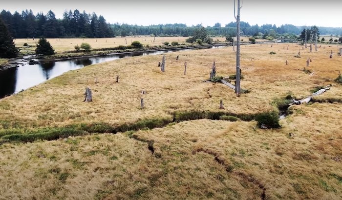
Back to 1700 --
How do you suppose this "Ghost Forest" on the Washington Coast near Copalis might support the claim that subduction zone events happen off the Pacific Northwest Coast?
HERE's a recap of additional evidence
Suffice to say that geologists are VERY confident in their claims that subduction zone events happen, on average every 300 - 500 years off the Pacific Northwest Coast.
═══════════════════════════
Back to tsunamis!
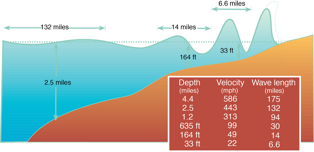
Take a look at this VERY cool graphic that shows how the principal characteristics of a tsunami (amplitude, wavelength, frequency, speed) change as it speeds across the Pacific.
This graphic is *Absolutely Critical* to our understanding of tsunamis and we will review it often over the next few days!
We'll now work on writing our own "Story" of a CSZ generated tsunami wave as it:
1) Heads towards and then impacts the Washington Coast
2) Heads east words across the Pacific and impact Hilo on the island of Hawaii.
Now please carve out about 3 - 4 feet of butcher paper and prepare the write the story of that tsunami. Even number groups will write/draw/sketch that wave as it heads towards Hawaii.
Odd number groups will write/draw/sketch that wave as it heads towards the Northwest Coast at Grays Harbor and Ocean Shores.
═══════════════════════════
═══════════════════════════
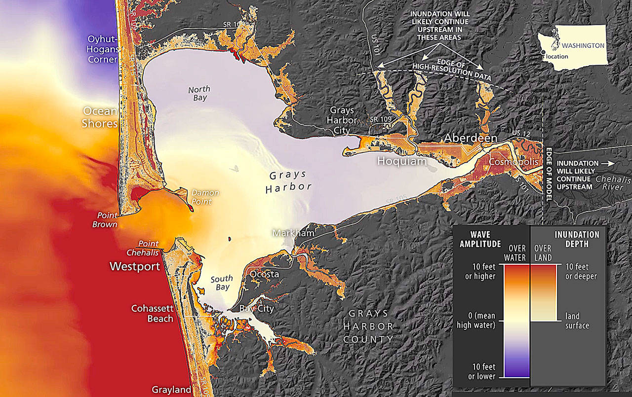
GRAYS HARBOR/OCEAN SHORES
Ocean Shores Inundation Scenario
HAWAII
It might surprise you to know that two separate tsunamis hit the "Big Island" of Hawaii in the middle of the last century (1946 and again in 1960)
Also please take a look at the underwater topography of the "Big Island". From that you should get a very good idea of why Hilo (You'll need to find it on the map) has suffered from repeated tsunami incidents over the centuries (Clicking on the image will bring up a LARGER version.
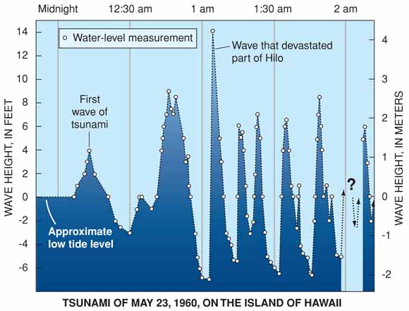
Check out this data:
How many waves struck Hilo?
What was the average period of those waves?
What was the amplitude of the highest wave?
═══════════════════════════
.jpg)